CariDotMy

 Forgot password?
 Register

ADVERTISEMENT

123Next
Return to list New
View: 17240|Reply: 51

Negara yang tidak ada sempadan darat utk crossing walaupun bersebelahan??

[Copy link]
Post time 9-11-2010 06:42 PM | Show all posts |Read mode
Boleh aku tahu, apa negara yang takda sempadan darat walaupun bersebelahan.....mesti ada sesuatu sbb terutamanya peperangan.....

yg aku tahu Bangladesh - Myanmar memang takda sempadan antarabangsa utk crossing walaupun berjiran.....

tqvm..


Rate

1

View Rating Log

Reply

Use magic Report


ADVERTISEMENT


 Author| Post time 9-11-2010 06:43 PM | Show all posts
Post Last Edit by RockerZin at 9-11-2010 18:46

          
Coordinates: http://maps.google.com/maps?f=q&source=s_q&hl=en&geocode=&q=myanmar&sll=21.070405,92.371674&sspn=0.68174,1.058807&ie=UTF8&hq=&hnear=Myanmar&z=6

          
Coordinates: View Larger Map">
View Larger Map
Reply

Use magic Report

Post time 9-11-2010 07:07 PM | Show all posts
wow hebat..
jgn bila org dh puji jd riak mcm org tu plak
Reply

Use magic Report

 Author| Post time 9-11-2010 09:10 PM | Show all posts
Reply

Use magic Report

 Author| Post time 9-11-2010 09:21 PM | Show all posts
Venezuela & Guyana pun takda land crossing....tak tahu juga kenapa ??

Copenhagen Climate Change Summit?  Venezuela's seemingly unwinnable battle against environmental devastation in southern jungles

VHeadline Venezuela News reports: As thousands marched against climate change ahead of the Copenhagen Climate Change Summit in Copenhagen (Denmark) next week, world leaders have urged rich countries to cut their emissions by at least 40% by 2020 and to provide US$150 billion a year by then to help the world's poor cope with the impact of climate change while increasing the supply of renewable energy.


In this picture cavalcade, we revisit the jungles and present the unblemished truth of Venezuela's dilemma...


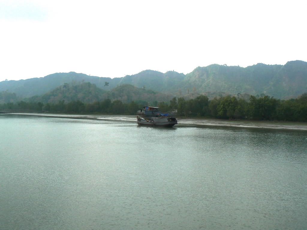
A tin-hulled 'lancha' plows along the mighty Cuyuni River in Venezuela's south-
eastern State of Bolivar close to the border with neighboring Guyana where it
joins the Essequibo River to flow into the southern Atlantic Ocean

The Rio Cuyuni is the culmination of many tributaries which drain the
gold-rich regions of Venezuela's Guayana region

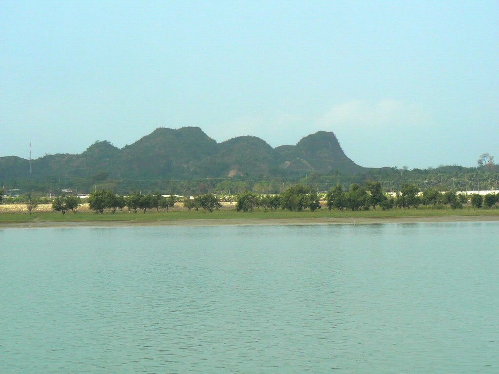
The Cuyuni River rises in the Guiana Highlands of Venezuela and descends north-
ward to El Dorado, where it turns east and meanders through tropical rainforests
forming the international boundary with Guyana for some 100 km (60 miles).

You may click on individual pictures to view a very much larger image:

Illegal miners have torched massive swathes of pristine rainforest in their
search for gold, regardless of the environmental damage they leave in their wake.

You may click on individual pictures to view a very much larger image:

The environmental damage caused to Venezuela's Amazonian rainforest
is plain to see for anyone and everyone who cares ... do you?


You may click on individual pictures to view a very much larger image:


Our pictures show illegal miners working in remote areas of the jungle
after they have burned the rainforest and water-blasted layers of earth
as they descend to the deposits of gold beneath the surface

You may click on individual pictures to view a very much larger image:

Behind them thy leave poisoned lakes and water tables

You may click on individual pictures to view a very much larger image:


The illegal miners (garimpieros) excavate huge holes in the rainforest floor while
living in crude wood and metal shacks close to the working in the remote jungle

You may click on individual pictures to view a very much larger image:

You may click on individual pictures to view a very much larger image:

You may click on individual pictures to view a very much larger image:

You may click on individual pictures to view a very much larger image:

You may click on individual pictures to view a very much larger image:

.

You may click on individual pictures to view a very much larger image:

Always there is environmental devastation to be found in the wake of illegal gold
mining operations with polluted pools an lakes throughout the Km 88 region.

The Kilometer 88 region of southern Bolivar State is already a "Lake District"
suffering from widespread pollution and devastated flora and fauna.

Closer to gold-mining operations at Las Cristinas and Las Brisas del Cuyuni,
illegal mining by garimpieros has left its indelible traces on the landscape.  An
eventual clean-up after more than 50 years of serious neglect is a major concern
to the Venezuelan Environmental & Natural Resources (MinAmb) Ministry and
will cost millions in funding that could otherwise be put to better use improving
the living standards of thousands of Venezuelans throughout the affected region.

Who with a conscience can condone this unbridled exploitation of the rainforest?

How long will the environmental devastation be allowed to continue?

Is it already too late?

Reply

Use magic Report

 Author| Post time 9-11-2010 09:22 PM | Show all posts
Reply

Use magic Report

Follow Us
 Author| Post time 9-11-2010 09:24 PM | Show all posts
Reply

Use magic Report

Post time 9-11-2010 09:28 PM | Show all posts
palestin ke israel pon ade land crossing jugak kan???
Reply

Use magic Report


ADVERTISEMENT


 Author| Post time 9-11-2010 09:29 PM | Show all posts
Teknaf(Naf river seperates Bangladesh from Myanmar/Burma)


Reply

Use magic Report

 Author| Post time 9-11-2010 09:55 PM | Show all posts
          
Coordinates: http://maps.google.com/maps?f=q&source=s_q&hl=en&geocode=&q=guyana&sll=-25.799891,-72.421875&sspn=131.395204,271.054688&ie=UTF8&hq=&hnear=Guyana&ll=5.145657,-60.611572&spn=5.81869,8.470459&z=7
Reply

Use magic Report

Post time 10-11-2010 07:58 AM | Show all posts
China (Tibet) dengan India ada tak?
Reply

Use magic Report

Post time 10-11-2010 09:02 AM | Show all posts
aku tak berapa paham lah maksud land crosing korang ni. ape benda sebenarnya ni ? kasik xplain la sikit.
Reply

Use magic Report

Post time 10-11-2010 11:58 AM | Show all posts
aku lagik tak paham???
Reply

Use magic Report

Post time 10-11-2010 12:25 PM | Show all posts
aku tak berapa paham lah maksud land crosing korang ni. ape benda sebenarnya ni ? kasik xplain la si ...
winamp05 Post at 10-11-2010 09:02


1. Entering into Myanmar is possible from China at the borderpost Ruili and onto Lashio (Myanmar). Totally overland, but you have to arrange visa, permit and guide to Lashio in Kunming (China). Not possible for independent travellers, you have to arrange things but if you are alone that is no problem at all. From Lashio you can travel further to all places in Myanmar without restrictions for travellers.
2. From Thailand there are 4 borders, 2 of which you can only cross for the day and travelling further is not at all possible: Mae Sot/Myawadi and Three Pagodas Pass.
3. The other two (Tachilek/Mae Sai and Kawthoung/Ranong) it is possible to travel into the country on a regular visa which you have to arrange before you enter the country and is valid for about a month. You can travel from Tachilek to Kengtung from where you need to fly (no land crossings possible by foreigners) to Heho or Mandalay or Yangon.
Also the other crossing involves flying or taking a boat from Kawthoung to Yangon, als no land transport possible.
4. And to end: it is possible to enter and exit in whatever way you want (fly in or by land) and you can leave from another route you took when entering the country. So flying in, and leaving by land is no problem and visa versa.
There even seems to be a possibility of leaving Myanmar overland into CHina (ruili again) but this is not verified by travellers so far and requires lots of waiting time for permits and lots of $$$

Rate

1

View Rating Log

Reply

Use magic Report

Post time 10-11-2010 12:53 PM | Show all posts
1. Entering into Myanmar is possible from China at the borderpost Ruili and onto Lashio  ...
Dunhill. Post at 10-11-2010 12:25 PM


still tak paham. ofkos la nak masuk negara orang lain kene ade visa / pasport bagai. tak paham tak paham. tolong la kasik paham.
Reply

Use magic Report

Post time 10-11-2010 02:33 PM | Show all posts
Negara bersebelahan yang takda sempadan utk menyeberang (tiada pegawai & imigresen) mungkin psl peperangan, perang dingin, mmg negera berkenaan menutup pintu utk org luar, hutan tebal, hutan simpan bermakna tidak dibuat jalan raya utk access ke negara sebelah dsb..

contoh paling baik yg boleh dilihat ialah Myanmar & Bangladesh.. walaupun Myanmar byk jiran, tp sempadannya dibuka dgn negara Thailand aja.. itupun org luar hanya boleh masuk pekan sempadan aja tak boleh ke ibu negara Rangoon..

my 2 sen

Rate

1

View Rating Log

Reply

Use magic Report


ADVERTISEMENT


Post time 10-11-2010 02:59 PM | Show all posts
singapore pun takdak apa..
Reply

Use magic Report

Post time 10-11-2010 03:36 PM | Show all posts
oo cmtu ker,,aku ingatkan myanmar dgn bangladesh ni,,dipisahkan oleh sungai je,,nak menyeberang kene naik bot,,tokleh lalu darat,,,
Reply

Use magic Report

Post time 10-11-2010 03:58 PM | Show all posts
ni kira faktor politik la ni. ingatkan faktor geografi. pasai tu aku tngk peta yg korang bagi aku tak paham paham.
Reply

Use magic Report

Post time 10-11-2010 03:59 PM | Show all posts
Paham dah paham dah
Reply

Use magic Report

You have to log in before you can reply Login | Register

Points Rules


ADVERTISEMENT


ADVERTISEMENT


ADVERTISEMENT
Follow Us

ADVERTISEMENT


Mobile|Archiver|Mobile*default|About Us|CariDotMy

15-2-2025 10:31 AM GMT+8 , Processed in 0.053800 second(s), 32 queries , Gzip On, Redis On.

Powered by Discuz! X3.4

Copyright © 2001-2021, Tencent Cloud.

Quick Reply To Top Return to the list