|
View: 4833|Reply: 10
|
[HISTORY OF GEOGRAPHY]: TUANAKI..MYTH ATAU TENGGELAM?
[Copy link]
|
|
|
Tuanaki mula masuk dalam annals sejarah apabila seorang pelayar merekodkan bahawa dia pernah tinggal bersama sekumpulan orang asli di sebuah pulau bernama Tuanaki selama 6 hari dan ia ditulis di dalam publication Polynesia Society of Honolulu pada tahun 1916. Dikatakan, ianya di selatan kepada Rarotonga, suatu pulau di dalam gugusan Cook Islands. Bila geng2 missionaries dapat tahu, mereka belayar kesana pada tahun 1844 nak sebar agama, tetapi tidak jumpa pun pulau Tuanaki ini.
Dari publication Polynesia Society of Honolulu inilah maka Sir Ernest Shackleton menjadikan satu dari aim beliau belayar ke Antartic ialah nak cari pulau ini; kita semua tahu apa jadi pada beliau dalam tahun 1921 / 22.
Ramai explorers mula minat pada pulau yang tak jugak2 ditemui ini, walaupun ada cerita kononnya orang asli Tuanaki boleh ditemui di Rarotonga. Namun ia hingga kini tetap tidak ditemui.
Sesetengah dari catatan tahun2 1840an, 1850an etc, telah di digitalzed (lihat dibawah). Lokasi asal Tuanaki adalah seperti dibawah. Ramai ahli sejarah kata, ianya myth, ramai pula kata ianya senasib dgn banyak pulau2 yang jauh dari land: ie tenggelam akhirnya.
|
This post contains more resources
You have to Login for download or view attachment(s). No Account? Register
x
Rate
-
1
View Rating Log
-
|
|
|
|
|
|
|
|
|
|
|
Edited by seribulan at 7-1-2021 11:27 AM
Dari bod sinun-
[url=]UserUPDATED 13 MARCH, 2020 - 20:47 APRILHOLLOWAYTen Legendary Lost Cities that Have Emerged from the Past
The story of Atlantis is one of the most renowned and enduring tales of a lost city, said to have been swallowed up by the sea and lost forever. Yet, the story of Atlantis is not unique, as other cultures have similar legends of landmasses and cities that have disappeared under the waves, been lost beneath desert sands, or buried beneath centuries of vegetation. Most of these legendary cities have never been found. However, there are now numerous cases of ancient cities, once seen as little more than myths and legends, that have now emerged from the past, raising the question as to how many more lost cities remain buried and waiting to be uncovered. 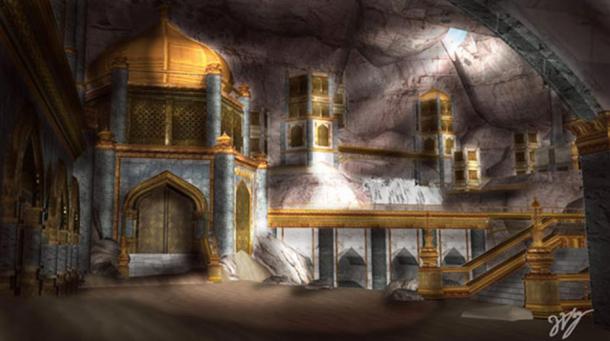 Atlantis of the Sands is a lost city, tribe, or area spoken of in the Quran, which has come to be known as Iram of the Pillars. In the Quran, Iram was said to be adorned with lofty buildings, and was populated by a group of people known as Ad. As they had turned away from Allah, the prophet Hud was sent to summon them to return to the worship of Allah and to obey Him. The people of Iram reacted with hostility and did not heed the words of Hud. As a result, legend says that the Ad were punished, and a sandstorm was sent against their city for seven nights and days. In the end, Iram vanished beneath the sands as tho Iram of the Pillars. This was achieved using NASA’s remote sensing satellites, ground penetrating radar, Landsat programme data, and images taken by the Space Shuttle Challenger. These resources allowed the team to identify old camel trade routes and the points at which they converged. One of these converging points was a well-known water hole at Shisr, in Dhofar province, Oman. When an excavation was carried out at the site, a large, octagonal fort with high walls and tall towers was uncovered. The team announced they had found the legendary Iram of the Pillars. While doubt still remains as to whether Ubar and Iram really are one and the same, it has been suggested that at the very least, the story of Iram was inspired by the city of Ubar, and over time became altered to incorporate a message to obey the will of Allah. The legendary ancient city of Helike was situated in Achaea, on the northwestern part of the Peloponnesian peninsula. During its heyday, it was the leader of the first Achaean League, a confederation that consisted of 12 cities in the surrounding area. Due to this position, Helike was an important economic, cultural and religious centre. The patron god of Helike was Poseidon, the Greek god of the sea and earthquakes. This is unsurprising, given Helike’s position in one of the most active earthquake zones in Europe.
One night during the winter of 373 B.C., the city of Helike was obliterated. Some signs of the city’s impending doom were recorded, including the appearance of ‘immense columns of flames’ and the mass migration of small animals from the coast to the mountains several days prior to the disaster. A major earthquake, followed by a large tsunami from the Gulf of Corinth, wiped the city of Helike from the face of the earth. The rescue party that came in the following morning found no survivors. Over time, the location of Helike was lost. In the early 19 th century, speculations about the actual site of Helike began to spread. However, it was not until 2001 that the ancient city was finally unearthed in Achaea, Greece. In 2012, the destruction layer was uncovered, which confirmed that the site is indeed Helike. The city of Heracleion, home of the temple where Cleopatra was inaugurated, plunged into the Mediterranean Sea off the coast of Egypt nearly 1,200 years ago. It was one of the most important trade centres in the Mediterranean before it sank more than a millennium ago. For centuries, the city was believed to be a myth, much like the city of Atlantis is viewed today. But in 2001, an underwater archaeologist searching for French warships stumbled across the sunken city.
After removing layers of sand and mud, divers uncovered the extraordinarily well preserved city with many of its treasures still intact including, the main temple of Amun-Gerb, giant statues of pharaohs, hundreds of smaller statues of gods and goddesses, a sphinx, 64 ancient ships, 700 anchors, stone blocks with both Greek and Ancient Egyptian inscriptions, dozens of sarcophagi, gold coins and weights made from bronze and stone. It was one of the most significant underwater discoveries in over a decade. Ancient Urkesh was once a major hub of the ancient Near Eastern Hurrian civilization, known in mythology as the home of a primordial god. It flourished between 4000 and 1300 BC as a major political and religious center, and an important stop on both the north-south trade route between Anatolia and the cities of Syria and Mesopotamia, and the east-west route that linked the Mediterranean with the Zagros Mountains of western Iran. It was also the capital of a kingdom that controlled the highlands immediately to the north where the supplies of copper were located, which made the city wealthy and rich. Little was known about Urkesh and the mysterious Hurrian civilization, as the ancient city had remained buried beneath desert sands for thousands of years, lost to the pages of history. However, in the 1980s, archaeologists discovered Tell Mozan, a towering mound that hid the remains of an ancient palace, temple, and plaza. A decade later, and researchers made the exciting realization that Tell Mozan was the lost city of Urkesh. The excavations revealed most of what is known today about the early culture of the Hurrian people. The uncovered remains of this fabled ancient city revealed an open plaza, a monumental flight of stairs and a deep underground shaft – the 'Passage to the Netherworld’ which was related to religious rituals. A large royal palace yielded written evidence that was able to identify the ancient city. During the sixth century, a legendary kingdom known as Cantre’r Gwaelod (meaning ‘The Lowland Hundred’) was said to have been ruled over by a king by the name of Gwyddno Garanhir. Up to around the 17th century, Cantre’r Gwaelod was known as Maes Gwyddno (meaning ‘Gwyddno’s Land’), so named after this Welsh ruler. An earlier version of the legend associated with Maes Gwyddno asserts that the land was submerged under water when Mererid, a priestess of a fairy well, allowed the water to overflow, sinking the kingdom forever. Several decades ago, the emergence of prehistoric forests during stormy weather in Cardigan Bay, in the west of Wales, led to the suggestion that it may be the location of the legendary Cantre’r Gwaelod. Indeed, investigations revealed a wattle walkway with associated posts, fossilized human and animal footprints, as well as some human tools. The location of the ancient kingdom is now believed to lie between Ramsey Island and Bardsey Island in Cardigan Bay, and to extend about 32 kilometers west of the current shoreline into the bay. Two years ago, an aerial search of the dense jungle of Honduras fuelled by local legends of a lost ancient city, revealed miles of seemingly man-made features. Announcements quickly spread that archaeologists had found La Ciudad Blanca (“The White City”), otherwise known as the Lost City of the Monkey God. But all they had to go on were vague scans of the jungle below. However, earlier this year, a ground expedition concluded its investigation and dramatically revealed that the aerial images did indeed show traces of a lost civilization. Archaeologists have now discovered extensive plazas, earthworks, mounds, an earthen pyramid, and dozens of finely carved artifacts belonging to a mysterious culture that is virtually unknown. La Ciudad Blanca is a legendary city that was said to be located in the virgin rainforest of Mosquitia in eastern Honduras. Spanish conquistador Hernán Cortés reported hearing "trustworthy" information about the ancient ruins, but never located them. In 1927, pilot Charles Lindbergh reported seeing monuments constructed from white stone while flying over eastern Honduras. By the 1930s, there were rumors of a place in Honduras called the "City of the Monkey God", which was equated with Ciudad Blanca, and in 1939 adventurer Theodore Morde claimed to have found it and brought thousands of artifacts back to the United States to prove it. According to Morde, the indigenous people said a giant statue of a monkey god was buried there. He never revealed the precise location of his find as he feared the site would be looted and died before returning to the site for a proper excavation. In 1952, explorer Tibor Sekelj searched for The White City on an expedition financed by the Ministry of Culture of Honduras, but returned empty handed. Investigations picked up pace in the 1990s following reports of the legend in popular media and in 2012 the first significant discovery was made. Investigations have now revealed an extensive complex that had lain untouched since the city was abandoned centuries, perhaps even millennia, ago. The temple of the ancient city of Musasir was an important Araratian temple dedicated to Haldi, the supreme god of the kingdom of Urartu, an Iron Age kingdom centered on Lake Van in the Armenian Highlands, which extended out across what is now Turkey, Iran, Iraq, and Armenia. The temple was built in the holy city of Ararat in 825 BC, but after Musasir fell to the Assyrians in the 8th century BC, the ancient temple became lost to the pages of history. The temple of Musasir dates back to a time when the Urartians, Assyrians, and Scythians were all at odds, trying to gain control over the area that is now known as northern Iraq. Ancient inscriptions referred to Musasir as a "holy city founded in bedrock" and "the city of the raven", while the name Musasir itself means “exit of the serpent”. A depiction of the temple appears in an Assyrian bas-relief which adorned the palace of King Sargon II at Khorsapat, to commemorate his victory over "the seven kings of Ararat" in 714 BC. Over the years, numerous studies and excavations were launched to try to locate the ancient temple of Musasir. All of them were unsuccessful until an expedition in July, 2014, when an exciting announcement was made – the long-lost temple of Musasir had finally been found. Located in the Kurdistan region of northern Iraq, the findings included life-sized human sculptures and column bases from a temple dedicated to the god Haldi, all dating back to the period in which the temple of Musasir was built. In 2014, Australian archaeologists using cutting edge remote-sensing technology made a remarkable discovery in Cambodia – a 1,200-year-old lost city that predates the Angkor Wat temple complex. Damian Evans, director of the University of Sydney's archaeological research center in Cambodia, and a small team working in the Siem Reap region, were given approval to use Lidar laser technology in the remote jungles of Cambodia, the first time the airborne technology has been used for archaeological research in tropical Asia. The discovery came when the Lidar data emerged on a computer screen. "With this instrument – bang – all of a sudden we saw an immediate picture of an entire city that no one knew existed, which is just remarkable," said Evans. The finding occurred after years of archaeological ground research to reveal Mahendraparvata, a lost city where people lived on a mountain called Phnom Kulen, 350 years before the building of the famous Angkor Wat temple complex in north-western Cambodia. It was part of the Hindu-Buddhist Khmer Empire that ruled much of Southeast Asia from about 800 to 1400 AD. Using the lidar data, the team of archaeologists discovered the ruins of five previously unrecorded temples, a huge statue of Buddha, evidence of ancient canals and roads and hundreds of mysterious mounds spread across the city, possibly tombs where the dead were buried. They also found a cave with historically significant carvings that was used by holy hermits who were common during the Angkor period. The research and excavation into the remarkable discovery of Mahendraparvata is still in its infancy and it is unknown what more the archaeologists will find there. It is widely taught in the field of ancient history that Mesopotamia, Egypt, China, and India, gave rise to the first civilizations of mankind. However, few are aware that at the same time, and in some cases before some of these societies emerged, another great civilization had sprouted - the Norte Chico civilization of Supe, Peru – the first known civilization of the Americas. Their capital was the Sacred City of Caral – a 5,000-year-old metropolis complete with complex agricultural practices, rich culture, and monumental architecture, including six large pyramidal structures, stone and earthen platform mounds, temples, amphitheatre, sunken circular plazas, and residential areas. The ancient city of Caral had lain buried beneath the sand for thousands of years until the Supe Valley, which lies 200 miles north of Lima on the Peruvian Pacific coast, was surveyed in 1905 by the German archaeologist Max Uhle, who revealed the first archaeological discoveries in the area. It was not until several decades later that full-scale excavations took place, revealing the tip of a very large iceberg. In the 1970s, archaeologists discovered that the hills originally identified as natural formations were actually stepped pyramids, and by the 1990s the full extent of the great city of Caral had emerged. Excavations revealed six large pyramids (platform mounds) arranged around a huge plaza. The public architecture has stairs, rooms, courtyards, an amphitheatre, and three sunken plazas. Accommodation seems to have consisted of large rooms atop the pyramids for the elite, ground-level complexes for craftsmen, and small outlying dwellings for workers. In total, it is estimated that Caral was home to a population of about 3,000 people. Researchers believe the model of the city was used by many civilizations that came after the Norte Chico. In 2014, archaeologists made an amazing discovery in the jungles of Mexico –two ancient Maya cities that had been lost over time, including ruined pyramid temples, palace remains, a monster mouth gateway, a ball court, altars, and other stone monuments. One of the cities had been found decades ago but all attempts to relocate the ruins, which are named Lagunita, had failed. The other city was previously unknown and was a brand new discovery, shedding new light on the ancient Maya civilization. One of the most impressive features of the Maya city is the enormous monster-mouth entranceway, which represents a Maya earth deity of fertility. Beyond the entranceway, archaeologists came across a large temple pyramid measuring 65 feet (20 metres) in height, as well as the ruins of a palace complex arranged around four large plazas. Nearby, they found numerous stone sculptures and several altars, all engraved with well-preserved reliefs and inscriptions. Even more stunning than the rediscovery of Lagunita, was the fact that the research team also stumbled across another set of ancient ruins nearby, which were previously unknown, including a pyramid temple, altar, and large acropolis surrounded by three temples. The researchers named the city Tamchen (‘deep well’), after finding more than thirty chultans, deep underground chambers used for collecting rainwater. Featured image: A compilation of lost cities that have since been found.
|
Rate
-
1
View Rating Log
-
|
|
|
|
|
|
|
|
|
|
|
ye, semakin lama dan semakin maju kita, semakin byk yg dijumpai.. contoh, berderet new mummies kat Egypt dijumpai last month tu.
|
|
|
|
|
|
|
|
|
|
|
|
Wah...zass terus cari info  Atlantis tu pun katanya kisah sejarah Melayu... Atlantis tu pun katanya kisah sejarah Melayu...
|
|
|
|
|
|
|
|
|
|
|
|
what??? sejarah melayu??
ha, berikan data2 nya pada saya
sy mahu baca
dah la dulu si Muammar Ghaddafi kata Shakespear tu keturuanna Libya ke apa..
|
|
|
|
|
|
|
|
|
|
|
|
Wow..Shakespeare?
Dulu ada benang pasal Atlantis ni benua Melayu di bod Epis...tak jumpa lak bila cari...
Nanti jumpa saya tepek...
Nah info ni-
Legend of the sunken Atlantis By B.A. Hamzah - December 16, 2016 @ 11:02am
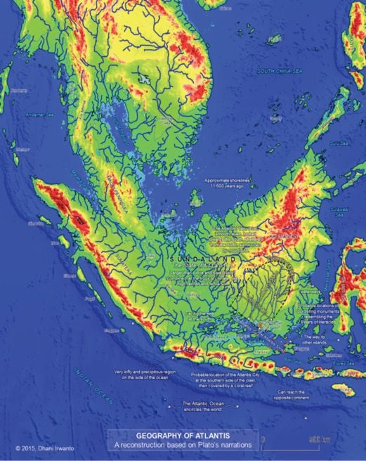
While the exact location of Atlantis is still being disputed, some believe it is in the Java Sea, which is prone to volcanic eruptions and tsunamis.
My heart pours out for folk in Aceh, who are struck by the recent earthquake. It is so devastating. I recall what happened on Boxing Day in 2004, when Aceh was shaken by tsunami, killing more than 160,000 people.
Many believe that a large volcanic eruption sunk Atlantis. It is more plausible to believe that Atlantis went underwater during the Ice Age when the sea level rose more than 150m.
Plato describes Atlantis as a “powerful and advanced kingdom that sank, in a night and a day, into the ocean around 9,600 BC”. The search for this submerged civilisation has resulted in expeditions to “many sites”, including the Greek island of Santorini, which was destroyed by a large volcanic eruption around 1,600 BC.
Expeditions to locate Atlantis were undertaken off Morocco, Spain, Portugal, Crete and Cuba, and some thought Atlantis is beneath the Antarctica.
In 1679, a Swedish scientist published a four-volume work proving that Sweden was the original site of the missing Atlantis. Few outside Sweden found his thesis convincing. None of these sites match the geographical descriptions Plato mentioned in his discourses.
A number of scholars working separately believe the mystery has been resolved.
Professor Arysio Santos, from Brazil, in his book Atlantis: The Lost Continent Finally Found, provided “evidence” that the Atlantis was part of the Sundaland.
His findings have inspired scientists like Dhani Iriwanto and Dr Danny Natawidjaya to dig deeper.
The former has published an interesting book — Atlantis: The Lost City Is in Java Sea (2015) — that says it all.
Natawidjaya captured my interest with a book that carries an interesting title: Plato Never Lied: Atlantis Is in Indonesia (2015).
In 1998, a reputed genetics expert at Oxford University published a monumental work, Eden in the East. In this book, Professor Stephen Oppenheimer suggests that the drowned continent of the Atlantis is probably in Southeast Asia.
His “discovery” has rekindled interest in other researchers, who believe that Plato’s “powerful kingdom and its civilisation” that went “underwater in a day and one night”, during the glacial age is actually the submerged Atlantis.
By studying the DNA of the descendants of the early migrants from Africa some 60,000 to 70,000 years ago, Oppenheimer was able to establish that the Malays of today’s Nusantara were originally from Africa. They were the first to occupy Sundaland, which included the sunken Atlantis.
According to Oppenheimer, there is a strong possibility that “the final dramatic rise in water level occurred between 8,000 and 7,000 years ago, the last of the series of emigration from the sinking Sunda Shelf began. The migration routes went south towards Australia, east towards the Pacific, west into the Indian Ocean and north into the Asian mainland”.
Oppenheimer has further suggested that the ancestors of “these people, and their Austro-Asiatic speaking neighbours now on the Asian mainland, founded the complex societies in Southeast Asia... in their dispersals the Southeast explorers fertilised the Neolithic cultures of China, India, Mesopotamia, Egypt and Crete”.
B.A. Hamzah is a student of regional geopolitics and defence policy, and a commentator on maritime security
|
Rate
-
1
View Rating Log
-
|
|
|
|
|
|
|
|
|
|
|
''lost city of java sea'' hmm.. baru sahaja di publish ni ie 2015
boleh kah kita yakini, kerana hanya this brazilian professor and this indonesian researcher sahaja yang berpendapat demikian
bila ianya didescribed dulu2 tu oleh plato, tentulah ianya di dalam limit of his knowledge, maka tentulah di dunia around dia sahaja.. ini tekaan saya saja lah
hmm macam susah nak yakinkan orang that atlantis could be in indonesia
malah, jika ianya betul2 di situ pun, nak convinced western minds ni memang susah
tentu akan diclaim oh architect2 kami pergi buat city tu disana ha ha
dasar pemikiran colonial omputeh
|
|
|
|
|
|
|
|
|
|
|
|
empire lemuria?
hmm hilang mcm Tuanaki juga ya?
sy still agak ragu2
betul kah wujud
|
|
|
|
|
|
|
|
|
|
|
|
Nasi tambah...
[size=19.1091px]Lemuria: The Fabled Lost Continent That Turned Out To Be Real — Almost
[size=19.1091px]By William DeLong
Published April 15, 2018
Updated June 8, 2020
[size=19.1091px]For decades, scientists offered wild theories about the fabled lost continent of Lemuria in the Indian Ocean. Then, in 2013, scientists actually found some evidence.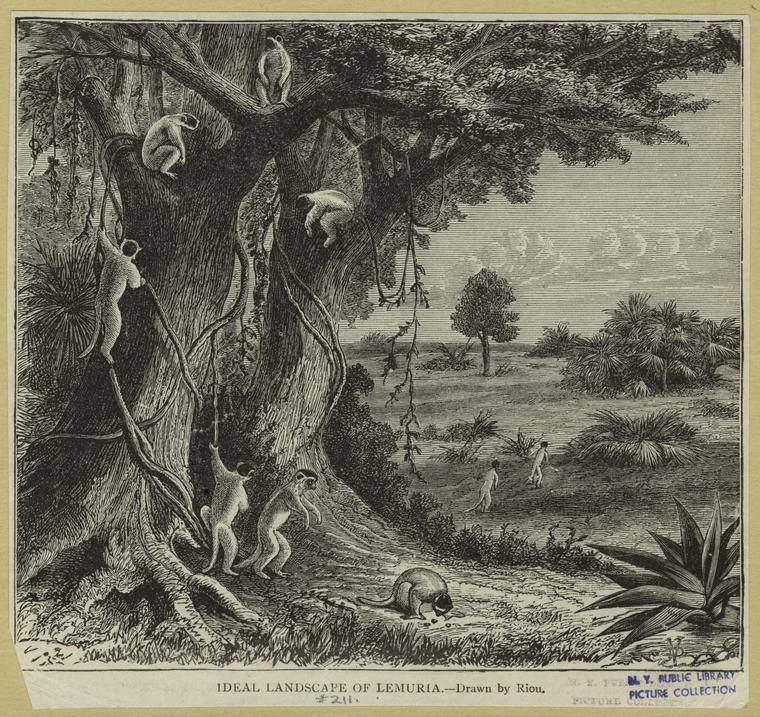 [size=0.75]Edouard Riou/New York Public LibraryA hypothetical rendering of Lemuria from 1893.
Forget all you know about plate tectonics, evolution, and the study of DNA for a moment. Back in the mid-1800s, a few scientists working from scant evidence decided there must have been a lost continent in the Indian Ocean and they called it Lemuria.
On this lost continent, some even thought, there once lived a race of now-extinct humans called Lemurians who had four arms and enormous, hermaphroditic bodies but nevertheless are the ancestors of modern-day humans (and perhaps also lemurs). And as absurd as this all sounds, the idea flourished for a time both in popular culture and some corners of the scientific community. Of course, modern science has long since debunked the idea of Lemuria altogether. But then, in 2013, geologists discovered evidence of a lost continent precisely where Lemuria was said to have existed and the old theories started cropping up once again.
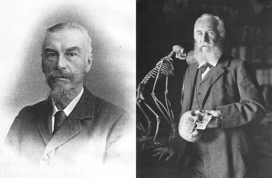 [size=0.75]Wikimedia CommonsPhilip Lutley Sclater (left) and Ernst Haeckel.
Lemuria theories first became popular in 1864, when British lawyer and zoologist Philip Lutley Sclater wrote a paper titled “The Mammals of Madagascar” and had it published in the The Quarterly Journal of Science. Sclater observed that there were many more species of lemur in Madagascar than there were in either Africa or India, thus claiming that Madagascar was the animal’s original homeland. Moreover, he proposed that what had allowed lemurs to first migrate to India and Africa from Madagascar long ago was a now-lost landmass stretching across the southern Indian Ocean in a triangular shape. This continent of “Lemuria,” Sclater suggested, touched India’s southern point, southern Africa, and western Australia and eventually sunk to the ocean floor.
This theory came at a time when the science of evolution was in its infancy, notions of continental drift weren’t widely accepted, and many prominent scientists were using land bridge theories to explain how various animals once migrated from one place to another (a theory similar to Sclater’s had even been proposed by French naturalist étienne Geoffroy Saint-Hilaire two decades earlier). Thus, Sclater’s theory gained some traction. Soon, other noted scientists and authors took the Lemuria theory and ran with it. Later in the 1860s, German biologist Ernst Haeckel began publishing work claiming that Lemuria was what allowed humans to first migrate out of Asia (believed by some at the time to be the birthplace of humanity) and into Africa. Haeckel even suggested that Lemuria (a.k.a. “Paradise”) may have been the very cradle of humankind itself. As he wrote in 1870:
“The probable primeval home or ‘Paradise’ is here assumed to be Lemuria, a tropical continent at present lying below the level of the Indian Ocean, the former existence of which in the tertiary period seems very probable from numerous facts in animal and vegetable geography.”
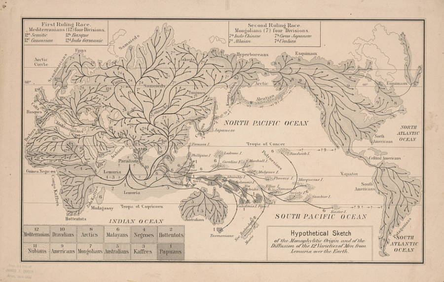 [size=0.75]Library of CongressA hypothetical map (believed to originate with Ernst Haeckel) depicting Lemuria as the cradle of humankind, with arrows indicating the theorized spread of various human subgroups outward from the lost continent. Circa 1876.
With help from Haeckel, Lemuria theories persisted throughout the 1800s and into the early 1900s (often discussed alongside the myth of Kumari Kandam, a proposed lost continent in the Indian Ocean that once housed a Tamil civilization). This was before modern science discovered ancient human remains in Africa that suggested that continent was actually the cradle of humankind. This was also before modern seismologists understood how plate tectonics moved the once-connected continents away from each other into their present forms.
Without such knowledge, many continued to embrace the notion of Lemuria, especially after Russian occultist, medium, and author Elena Blavatskaja published The Secret Doctrine in 1888. This book proposed the idea that there were once seven ancient races of humanity and that Lemuria had been the home of one of them. This 15-foot-tall, four-armed, hermaphroditic race flourished alongside the dinosaurs, Blavatskaja said. Fringe theories even suggested that these Lemurians evolved into the lemurs we have today. Afterward, Lemuria understandably found its way into novels, movies, and comic books well into the 1940s. Many people saw these works of fiction and wondered where authors and filmmakers got these fanciful ideas. Well, they got their ideas from scientists and writers about 75 years before.  [size=0.75]Sofitel So Mauritius/FlickrMauritius
Fast forward to 2013. Any scientific theories of a lost continent and land bridge responsible for the migration of lemurs is gone. However, geologists have now discovered traces of a lost continent in the Indian Ocean. Scientists found fragments of granite in the ocean south of India along a shelf that extends hundreds of miles south of the country towards Mauritius. On Mauritius, geologists found zircon despite the fact that the island only came into being 2 million years ago when, thanks to plate tectonics and volcanoes, it slowly rose out of the Indian Ocean as a small landmass. However, the zircon they found there dated to 3 billion years ago, eons before the island had even formed.
What this meant, scientists theorized, was that the zircon had come from a much older landmass that long ago sunk into the Indian Ocean. Sclater’s story about Lemuria was true — almost. Rather than call this discovery Lemuria, geologists named the proposed lost continent Mauritia. Based on plate tectonics and geological data, Mauritia disappeared into the Indian Ocean around 84 million years ago, when this region of Earth was still turning into the shape it holds today. And while this generally lines up with what Sclater had once claimed, the new evidence puts the notion of an ancient race of Lemurians that evolved into lemurs to rest. Mauritia disappeared 84 million years ago, but lemurs didn’t evolve on Madagascar until about 54 million years ago when they swam to the island from mainland Africa (which was closer to Madagascar than it is now).
Nevertheless, Sclater and some of the other scientists of the mid-1800s were partially right about Lemuria despite their limited knowledge. A lost continent didn’t suddenly sink into the Indian Ocean and vanish without a trace. But, long ago, there was something there, something that is now gone forever.
|
Rate
-
1
View Rating Log
-
|
|
|
|
|
|
|
|
|
|
|
i see
nanti sy cuba tgk if there are more infos pasal lemuria ni
patut cik seri bukak thread asing utk nya
|
|
|
|
|
|
|
|
|
|
| |
|